
Associate Professor of Chemistry, University of Richmond

Deep-frying a turkey is a great way to get a delicious, moist meal for Thanksgiving. But this method of cooking can be a very dangerous undertaking.

Every fall, millions of dollars of damage, trips to the ER and even deaths result from attempts to deep-fry turkeys. The vast majority of these accidents happen because people put frozen turkeys into boiling oil. If you are considering deep-frying this year, do not forget to thaw and dry your turkey before placing it in the pot. Failure to do so may lead to an explosive disaster.

What is so dangerous about putting even a partially frozen turkey in a deep-fryer?

I’m a chemist who studies plant, fungal and animal compounds and have a love of food chemistry. The reason frozen turkeys explode, at its core, has to do with differences in density. There is a difference in density between oil and water and differences in the density of water between its solid, liquid and gas states. When these density differences interact in just the right way, you get an explosion.

A cup filled with a layer of oil sitting on top of a layer of water.
If water and oil are in the same container, the denser water will sink to the bottom. Daniel Merino, CC BY-ND

Understanding density

Density is how much an object weighs given a specific volume. For example, imagine you held an ice cube in one hand and a marshmallow in the other. While they are roughly the same size, the ice cube is heavier: It is more dense.

The first important density difference when it comes to frying is that water is more dense than oil. This has to do with how tightly the molecules of each substance pack together and how heavy the atoms are that make up each liquid.

Water molecules are small and pack tightly together. Oil molecules are much larger and don’t pack together as well by comparison. Additionally, water is composed of oxygen and hydrogen atoms, while oils are predominantly carbon and hydrogen. Oxygen is heavier than carbon. This means that, for example, one cup of water has more atoms than one cup of oil, and those individuals atoms are heavier. This is why oil floats on top of water. It is less dense.

While different materials have different densities, liquids, solids and gases of a single material can have different densities as well. You observe this every time you place an ice cube in a glass of water: The ice floats to the top because it is less dense than water.

When water absorbs heat, it changes to its gas phase, steam. Steam occupies 1,700 times the volume as the same number of liquid water molecules. You observe this effect when you boil water in a tea kettle. The force of expanding gas pushes steam out of the kettle through the whistle, causing the squealing noise.

Frozen turkeys are filled with water

A man in a fire suit placing a turkey in a fryer.
Deep-frying a turkey can be safe as long as the turkey is thawed and dried. YinYang/E+ via Getty Images

Frozen turkeys – or any kind of frozen meats, for that matter – contain a lot of ice. Raw meat can be anywhere from 56% to 73% water. If you have ever thawed a frozen piece of meat, you have probably seen all the liquid that comes out.

For deep-frying, cooking oil is heated to around 350 degrees Fahrenheit (175 C). This is much hotter than the boiling point of water, which is 212 F (100 C). So when the ice in a frozen turkey comes in contact with the hot oil, the surface ice quickly turns to steam.

This quick transition is not a problem when it happens at the very surface of the oil. The steam escapes harmlessly into the air.

However, when you submerge a turkey into the oil, the ice inside the turkey absorbs the heat and melts, forming liquid water. Here is where the density comes into play.

This liquid water is more dense than the oil, so it falls the bottom of the pot. The water molecules continue to absorb heat and energy and eventually they change phases and become steam. The water molecules then rapidly spread far apart from one another and the volume expands by 1,700 times. This expansion causes the density of the water to drop to a fraction of a percent of the density of the oil, so the gas wants to quickly rise to the surface.

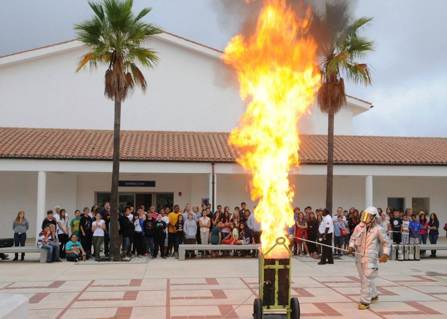
Combine the fast change in density together with the expansion of volume and you get an explosion. The steam expands and rises, blowing the boiling oil out the pot. If that weren’t dangerous enough, as the displaced oil comes into contact with a burner or flame, it can catch fire. Once some droplets of oil catch on fire, the flames will quickly ignite nearby oil molecules, resulting in a fast-moving and often catastrophic fire.

Every year, thousands of accidents like this happen. So, should you decide to deep-fry a turkey for this year’s Thanksgiving, be sure to thoroughly thaw it and pat it dry. And next time you add a bit of liquid to an oil-filled pan and end up with oil all over the stove, you’ll know the science of why.

This article originally appeared on The Conversation. You can read it here.
  • New world map makes Africa look bigger: what’s the fuss about? Cartographers explain
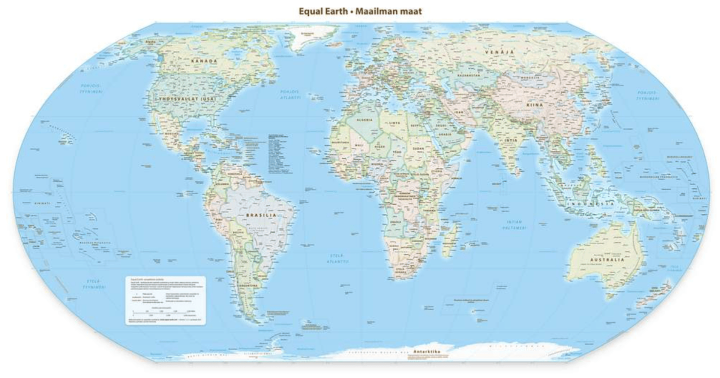
    A political wall map using the Equal Earth projection centred at the prime meridian. Wikimedia Commons

    The UN has passed a non-binding resolution to endorse the Equal Earth Projection, a map which more fairly represents the true size of the Earth’s landmasses. The current commonly used projection, called the Mercator Projection, greatly exaggerates land towards the north and south poles, which makes Africa look much smaller. In the Mercator projection, countries near the north and south pole can be anywhere from two to 14 times their true size. In the Equal Earth projection these distortions are minimised, making Africa look larger in comparison.

    We asked Jack Swab and Derek Alderman, cartographers and geographers who study the social and communicative power of maps, to explain what’s going on.


    What is a map projection?

    A map projection is a technique that cartographers (map-makers) use to transform the round, three-dimensional Earth into a flat, two-dimensional map that we see on the wall or on our computer screen. As cartographers flatten the globe, the map becomes distorted, changing shapes and areas. There is no map projection that does not distort the Earth, but some projections are better suited for some uses than others.

    A cartographer’s job is to choose from the hundreds of different map projections, and consider where the map is focused and how it is going to be used. No single projection is best for every use. This new Equal Earth projection is better suited than Mercator for producing global scale world maps for educational, public communication and policy purposes.

    The Equal Earth supports a more accurate geographic understanding of the relative sizes of countries and continents. It provides a fairer perspective for the public to compare regions in terms of population, environment, development, politics and other global patterns.

    Is the Mercator projection still useful?

    While the Mercator projection isn’t good for showing the size of the Earth’s landmasses, we won’t see it totally disappear. For example, it’s very useful for navigational purposes as it maintains the accuracy of a compass bearing between two points without having to recalculate it.

    This is why most online mapping platforms like Google Maps or Apple Maps rely on a variation of the Mercator projection to provide directions. Using the Equal Earth projection for navigation would not be as effective as the Mercator projection.

    How will the Equal Earth projection be used?

    Map-making is decentralised and there is no single authority regulating which map projection is used. What the UN did was endorse the broader message that Equal Earth is a fairer projection that more equitably displays the true size of the Earth’s land. And although this action is happening at a global level, there are movements underway in cartographic communities to make the Equal Earth projection the default world map projection.

    The UN resolution by itself will not make Equal Earth a globally adopted projection. That requires intentional revision of maps used in textbooks, databases, media productions and diplomatic discussions, which requires labour and financial investment.

    The Equal Earth projection was developed by cartographers and is a popular choice among map-makers since it was unveiled in 2018. It’s now possible to buy wall maps with the Equal Earth projection on them, and the projection has already been used in a wide variety of media. That said, individuals will need to opt in to using the Equal Earth projection over other types.

    Why has the Equal Earth projection sparked resistance?

    Resistance to the Equal Earth projection has been quite limited. There were several abstentions from the United Nations General Assembly vote, but most of this was for other reasons. Ukraine, for example, raised concerns over the depiction of the contested Crimean Peninsula on the map, which the Equal Earth Projection website depicts as contested territory.

    This spurred a Russian response, along with points from other nations about contested territory. Given the UN resolution was a vote on how the world is portrayed and not about any specific political boundaries (a point that both Russia and Ukraine agreed on), these discussions amounted to geopolitical posturing about non-map issues.

    The lone outlier, and only “no” vote against the Equal Earth projection, came from the United States. It claimed that the proposal was part of a “radical and ideological project” that was not appropriate for the United Nations to be debating. American delegates took issue with language linking Mercator’s distortions to colonial legacies and the marginalisation of Africa. This is not surprising since the current administration denies the existence of structural systems of inequality.

    It is hard to miss the hypocrisy at play. The US wants other countries not to discuss the political implications of cartography even as President Trump engages in his own nationalist branding of the map. He has unilaterally renamed the Gulf of Mexico to the Gulf of America and Lake Ontario to Lake America for clear ideological reasons and without international consultation.

    How does the new map matter when it comes to changing global views of the world?

    The argument that African nations put forward was that the Equal Earth projection is a form of “cognitive justice”. Cognitive justice recognises that people often equate power and value of places with their apparent size on maps. Traditional views of Africa as a smaller continent compared to Europe or North America typically reflect the perceived importance of these parts of the world.

    Equal Earth may make it easier to teach, broadcast and discuss a different view of Africa and its prominence in the world. Today, African countries are among the world’s fastest growing economies and fastest growing populations. Map projections alone cannot change people’s attitudes. Yet, as African nations seek to have more influence in international affairs, correcting the mental map of global leaders is an important step in amplifying the continent’s relevance and rights.

    Jack Swab, Assistant Professor Department of Geography & Sustainability, University of Tennessee and Derek H. Alderman, Chancellor’s Professor of Geography, University of Tennessee

    This article originally appeared on The Conversation. You can read it here.

  • Earth’s missing continent rediscovered 375 years after sailors first set foot there
    Though mostly submerged now, Zealandia is a real place.
    ,

    Earth’s missing continent rediscovered 375 years after sailors first set foot there

    Long overlooked and mostly underwater, Zealandia is rewriting what we know about Earth’s continents.

    Earth still holds remarkable secrets beneath its surface—and sometimes beneath its oceans. In 2017, scientists confirmed the existence of a hidden continent beneath the South Pacific. Now known as Zealandia, this mostly submerged landmass was found hiding in plain sight and has since been dubbed “the eighth continent.” A study published in Tectonics helped solidify its status, offering a new perspective on Earth’s ever-evolving geography.

    The long search that began in the 1600s

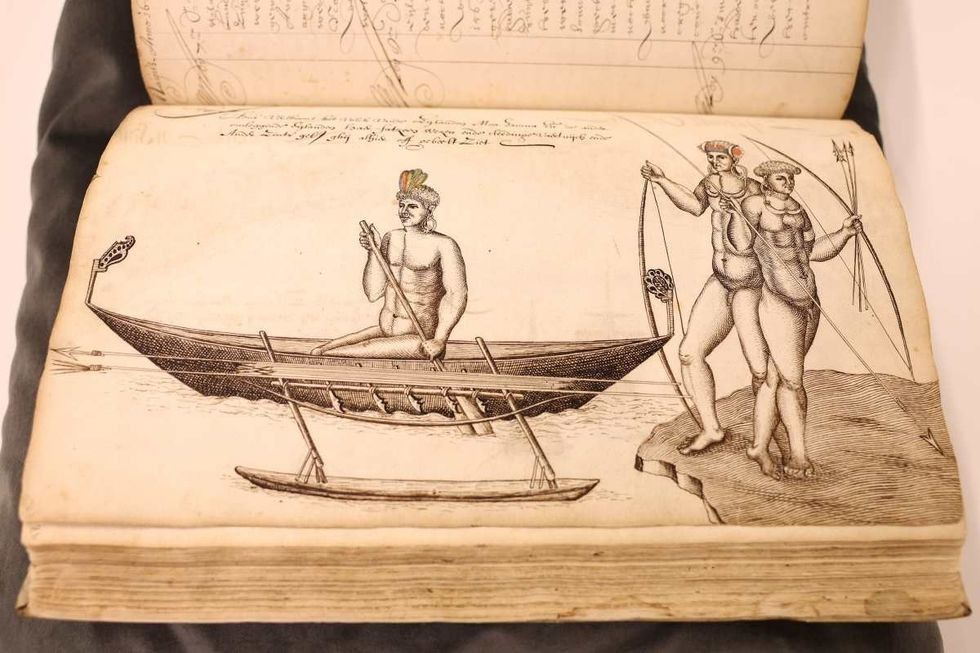
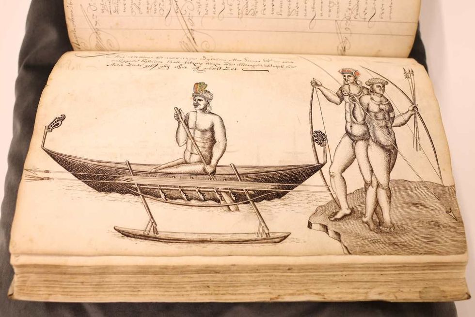
    Although the researchers discovered this new continent in 2017, the hunt began almost 400 years ago. In 1642, Dutch captain Abel Tasman (seen in the above portrait), serving the East India Company, was ordered to explore a Southern Continent. On August 14, 1642, Tasman departed from Batavia with two ships sailing west to Mauritius in the Indian Ocean, according to Princeton University Library.

    zealandia, logbook, lost continent
    A detailed view of the logbook of navigator Abel Tasman (Dutch East India Company) from 1642 Dean Mouhtaropoulos/Getty Images

    Tasman named the location “Moordenaers (Murderers) Bay,” and sailed home, never to return to this land, although he did believe that he had discovered a great new continent.

    Naming and defining Zealandia

    It was nearly 375 years after Tasman’s voyage that geologists stumbled upon this mainland. They announced the discovery by naming it “Zealandia,” based on the suggestion of American geophysicist Bruce Luyendyk who described this region in 1995. Zealandia is translated to “Te Riu-a-Māui” in the Māori language.

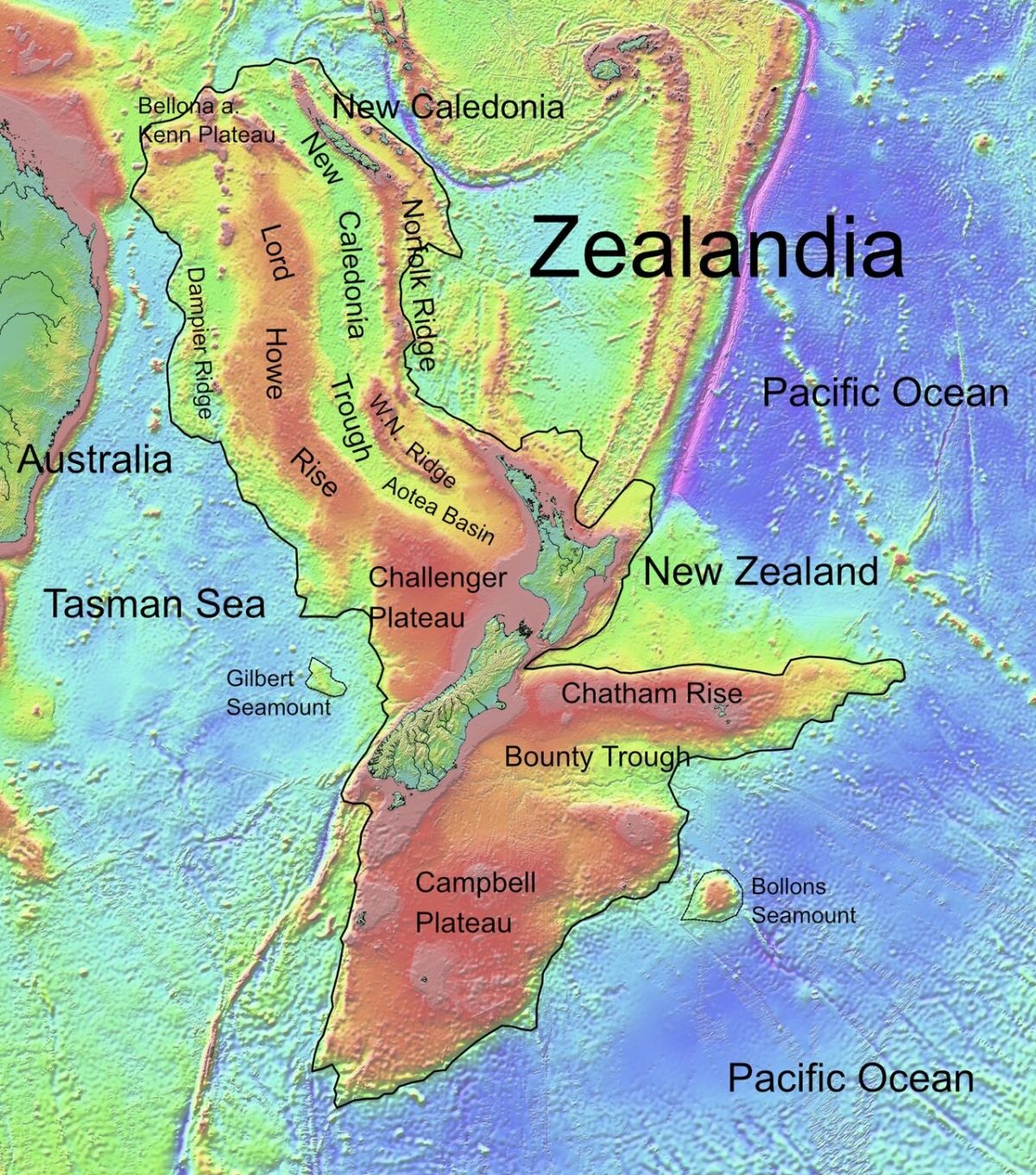
    Zealandia lies mostly submerged off the east coast of Australia Public Domain

    In a paper, researchers from GNS Science of New Zealand documented that they had to dredge rock samples from the Fairway Ridge to the Coral Sea to analyze the rock geochemically and understand the underwater makeup of Zealandia. Led by Nick Mortimer, they scanned the northern two-thirds of the submerged area, where they unearthed pebbly and cobbley sandstone, fine-grain sandstone, mudstone, bioclastic limestone, and basaltic lava from a variety of periods as concluded by their radiocarbon dating.

    Ancient rocks with a story to tell

    The rocks and stones were found to be roughly 95 million years old, from the Late Cretaceous period. The granite and volcanic pebbles were estimated to be 130 million years old, the Early Cretaceous period. The basalts however were newer, probably about 40 million years old, and from the Eocene period. “It is kind of cool,” said Mortimer, per BBC. Andy Tulloch, a geologist at the New Zealand Crown Research Institute GNS Science, who was part of the research team, added, “This is an example of how something very obvious can take a while to uncover.”

    Mostly submerged, yet massive

    Although Zealandia is a vast continent that spans an expanse stretched for 4.9 million square kilometers, around six times the size of Madagascar, most of it is submerged under the South Pacific Ocean. Only the area at the Ball’s Pyramid on Lord Howe Island rises above the water’s veil. It is the smallest, thinnest, and youngest of all known continents.

    Usually, the continental crust is about 40 kilometers deep, thicker than the oceanic crust which is about 10 kilometers. The researchers proposed that since Zealandia ended up stretched too much, its crust became thinner, around 20 kilometers, and finally disappeared under the sea. With 95 percent of its territory submerged beneath the ocean’s depths, Zealandia prowls on planet Earth as a lair possessing an enigmatic charm of mysterious historical elements and ancient stories.

    This article originally appeared last year.

    This article originally appeared 1 year ago. It has been updated.

  • ‘Star Trek’ and NASA have intertwined legacies – the show championed diversity and inspired generations of real space scientists
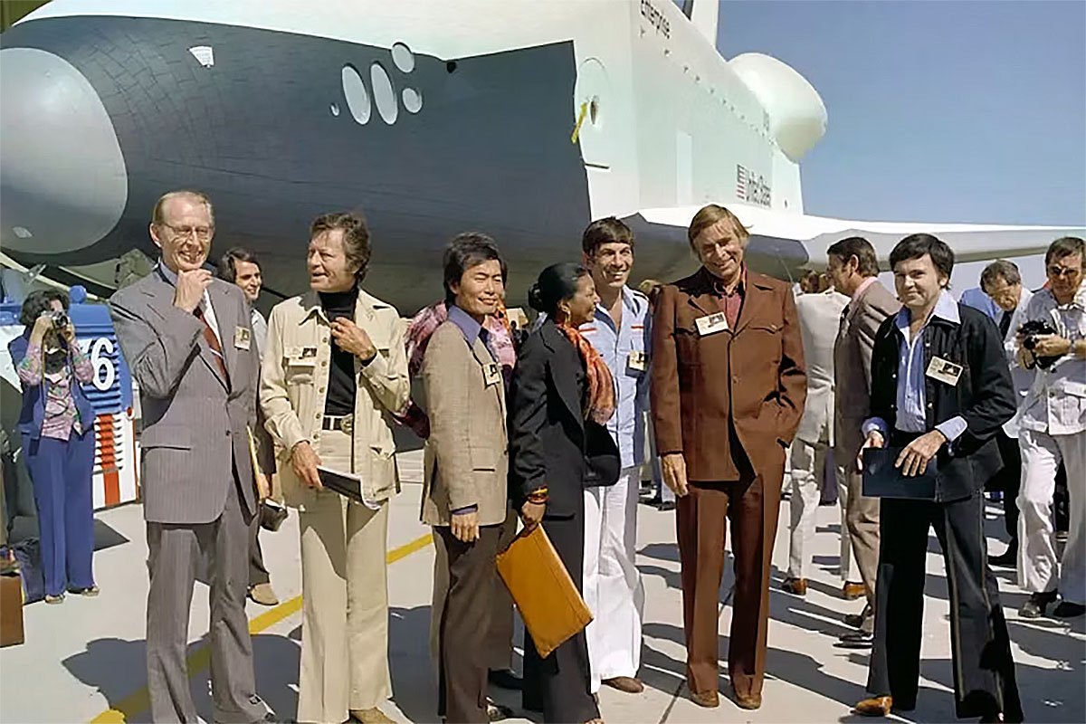
    Photo credit: NASA – Gene Roddenberry, second from right, and Star Trek cast members visit the Space Shuttle Enterprise in 1976 with NASA Administrator James C. Fletcher, left. NASA

    “Star Trek” began as a television series but grew into a cultural phenomenon.

    When it premiered in 1966, no one could have predicted that it would lead to more than a dozen spinoff shows, more than a dozen movies and one of the most enduring fandoms in popular culture.

    “Star Trek” is also unusual for its close connections to NASA, both in its storylines and in the real world. Decades of “Star Trek” adventures have ignited a love of spaceflight across generations, inspiring many who now work as space professionals.

    I’m a cultural anthropologist who studies why people work in space exploration. I’ve interviewed astronomers, engineers, flight surgeons and astronauts. Although I focus more on science fact than science fiction, I’ve noticed in my interviews how much the two threads intertwine.

    Because of this, I found myself at a “Star Trek” convention in early August 2026, just ahead of the show’s 60th anniversary on Sept. 8. The convention participants included people of widely different ages, appearances and identities. I was struck by just how much those gathered reflected the series’ values.

    When NASA met Star Trek

    In the original series, the show’s creator, Gene Roddenberry, came up with a philosophy held by the Vulcan people. He called it IDIC: infinite diversity in infinite combinations. It suggests that an ideal society is made up of many different types, all working together.

    It represented Roddenberry’s rejection of conformity. It also explained why the Enterprise crew included a Russian alongside Americans, and Black, Japanese and female characters all in positions of responsibility and authority. While many ordinary viewers absorbed “Star Trek’s” lessons of camaraderie and acceptance, those involved in real space exploration also took notice.

    A black-and-white photo of four characters wearing Starfleet uniforms, including two white men, an Asian man and a Black woman.
    The cast of ‘Star Trek: The Original Series’ included a diverse crew of characters. Walters Art Museum

    Roddenberry established relationships with NASA personnel in the early days of his series. NASA provided photographs of planetary bodies and advice about the realities of spaceflight, as well as stock footage and access to certain NASA facilities.

    Leonard Nimoy, who played the popular character Mr. Spock, was even brought to the National Space Club’s Goddard Memorial Dinner in 1967 as a special guest. Then-Vice President Hubert Humphrey gave the keynote speech. Afterward, though, it was Nimoy, not Humphrey, who found himself surrounded by the club’s members, including NASA employees, aerospace engineers, members of the military and government officials, all eager to meet the actor portraying the starship Enterprise’s first officer.

    The relationship between NASA and “Star Trek” benefited the show by legitimizing the series. It also helped NASA by publicizing its work and depicting a positive future where its efforts to land on the Moon would eventually lead to visits to distant worlds – and amazing scientific advances like the show’s transporter and warp drive.

    The connection between the space show and space agency was reflected in NASA’s decision to name its first space shuttle Enterprise, after some encouragement from the “Star Trek” fan community.

    Inspiring astronauts

    In 1977, actress Nichelle Nichols, who portrayed communications officer Uhura, was hired to recruit for NASA. The space agency had expanded its pool of astronauts to include scientists and other “mission specialists.” For the first time, an astronaut no longer needed to be a pilot to participate in a space mission.

    NASA selected its first Black astronaut candidates and its first female astronaut candidates in 1978. While this move toward inclusivity may not have been directly influenced by infinite diversity in infinite combinations, it was compatible with it. “Star Trek” inspired many of NASA’s future employees. In interviews for my book “The Ultraview Effect,” a quarter of the space professionals I spoke with mentioned “Star Trek” as an influence.

    A woman wearing a blue jumpsuit sitting in the pilot's chair in a space shuttle cockpit simulator
    Nichelle Nichols sits in the space shuttle simulator at the Johnson Space Center in March 1977. NASA

    An Apollo astronaut I interviewed, for instance, said he believed humans would eventually “be able to go anywhere in the universe, just like ‘Star Trek.’”

    A young engineer who had grown up in the 1990s told me his motivation came from the “opening line of ‘Star Trek’… to explore strange new worlds.”

    A space shuttle mission specialist emphasized Roddenberry’s decision to make the starship crew multicultural, explaining: “Today I look at the diversity of it … he was setting the stage back when it wasn’t acceptable [in order] to be acceptable!”

    A changing future

    That influence has accompanied a changing astronaut corps.

    Both the 2025 astronaut class, which for the first time included more women than men, and the crew of Artemis II, which sent the first woman, first Black astronaut and first Canadian on a lunar mission, resemble the future that “Star Trek” imagined.

    The “Star Trek” fans at the convention I attended were even more diverse. It was clear to me that Roddenberry’s “infinite diversity in infinite combinations” isn’t just a concept from the series, but something that has become a defining value of contemporary Trek fandom.

    A photo of space, with some bright spots representing nebulae, including a bright spot that looks like the disc-shaped hull of the starship Enterprise from Star Trek
    NASA’s Spitzer Space Telescope captured a region of the galaxy that looks a little like the USS Enterprise, which NASA highlighted in a news release in 2016. NASA/JPL-Caltech

    One such fan, Bjo Trimble, holds special status. She is credited with “saving ‘Star Trek’” when the series was almost canceled in 1968 after two seasons. Wearing a rainbow “IDIC” pin, she signed autographs at the SyFy Sistas booth, where T-shirts featuring Black “Star Trek” icons such as Uhura and Benjamin Sisko were on display.

    However, with the Trump administration’s recent orders to dismantle all of NASA’s diversity, equity, inclusion and accessibility programs and policies, institutional support for “Star Trek’s” vision of acceptance and inclusivity, which flourishes in its fan base, is being undone. This rollback occurred just as NASA’s crews were reaching new milestones in representing the diverse future that “Star Trek” has encouraged for decades.

    Sixty years later, some of the diverse future that “Star Trek” imagined has become part of everyday spaceflight. Other parts of that ideal remain unfinished.

    This article originally appeared on The Conversation. You can read it here.

Explore More Science Stories

Science

Tiny backpacks reveal the secret, sometimes circuitous migrations of small songbirds

Science

Why fall yard care could start with doing less – but not nothing

Science

New world map makes Africa look bigger: what’s the fuss about? Cartographers explain

Technology

Only 17% of people can pass this 3-question IQ test on the first try. Can you?