
James Smithson Postdoctoral Fellow, Smithsonian Institution

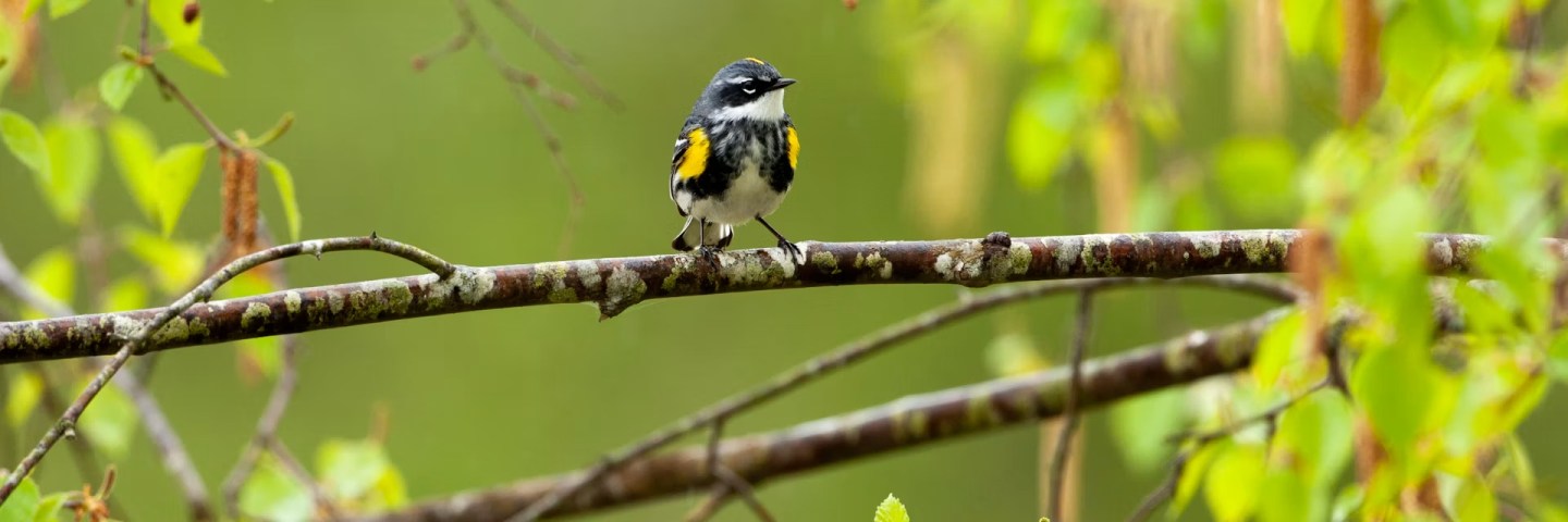
Squinting through my binoculars, I scanned the dense branches of a black spruce, trying my best to catch a glimpse of the thin legs of a small black, white and yellow songbird. I was on the hunt for a yellow-rumped warbler – a bird affectionately called “butter-butt” by bird-watchers after the distinctive buttery yellow patch of feathers above its tail.
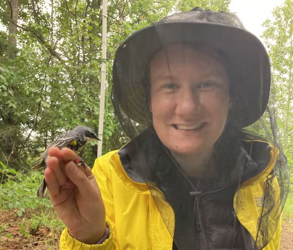
A woman in a veiled hat holds a small bird with red and yellow bands on its legs.
Stephanie Szarmach holds a yellow-rumped warbler that was banded as part of a study. Johanna Beam

Once I spotted a flash of red on one of the bird’s legs, I knew that this individual was special – in fact, it was one that I already knew well. That’s because I had placed identifying bands on it the previous year as part of my Ph.D. research, and it was carrying a very important piece of new technology.

I played the high pitched “warble” of its song through a speaker placed below a mist net of fine, nearly invisible mesh. Thinking another male had intruded on his territory, the bird quickly descended. My tactic worked – he got caught in the net. As I gently removed him, I breathed a sigh of relief as I saw the Tic Tac-size device sitting on his back.
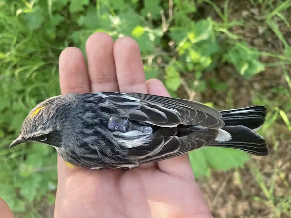
A hand holding a bird that has a small grey device on its back
A yellow-rumped warbler wears a multisensor geolocator backpack. Stephanie Szarmach

Over the past year, this warbler carried a multisensor geolocator backpack throughout his migratory journey, recording the long trek from his breeding grounds in Anchorage, Alaska, to a yet unknown winter refuge and back again. Working with my Ph.D. adviser, evolutionary biologist David Toews, I deployed dozens of these cutting-edge tags to illuminate the migratory journeys of these high-latitude breeding warblers at a scale not previously possible for small birds.

Now, after a year of waiting, I finally had the data in hand.

How can scientists track small birds?

Researchers began tracking the movements of migrating birds in the late 1960s using radio telemetry, a technique that requires tagged birds to be physically followed with receiver equipment, sometimes aided by a small aircraft.

Then, as GPS became more widely available in the early 2000s, satellite tags let researchers accurately track birds remotely. However, GPS transmitters are hefty – even just the battery that powers them is too heavy to be carried by the majority of small migratory songbirds, which often weigh less than a spoonful of sugar.

To address this problem, researchers developed ingenious little light-level geolocators. These miniature tags minimize weight by containing only a tiny battery, clock, computer chip and light sensor. They store data internally rather than transmitting it – hence my need to recapture tagged birds a year later. Researchers infer a bird’s locations from the timing of sunrise and sunset, which vary predictably across the globe and throughout the year.

Light-level geolocators have opened new windows into the migrations of small birds, but they also have limitations: Their estimated locations can err by hundreds of miles, and this uncertainty becomes impractically high around the equinoxes, when day length is the same worldwide.
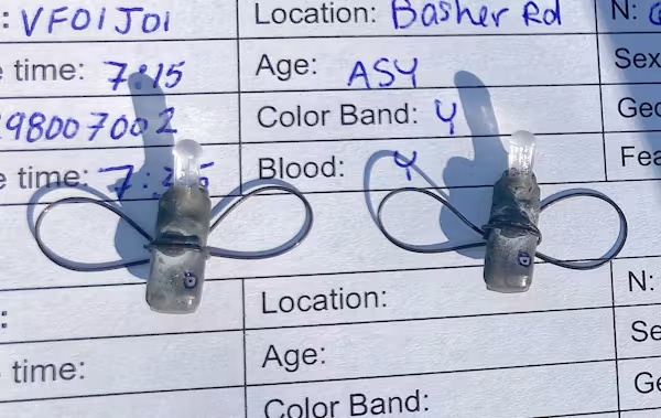
Two small grey devices sitting on a scientific data sheet.
Each harness loop of the multisensor geolocator goes around one of the bird’s legs and the tag sits on the bird’s lower back. Stephanie Szarmach

More recently, researchers developed a newer method of geolocation that uses atmospheric pressure to circumvent these limitations. When a bird ascends during a migratory flight, a barometric geolocator records a steep drop in air pressure, capturing the timing of departure and arrival for every stop along a bird’s migration route. In between flights, the pressure the tag records reflects the elevation at the bird’s position.

Knowing the bird’s elevation helps to narrow down possible locations, which researchers can then refine further by comparing the change in pressure over time recorded by the tag to global weather data using the computer program GeoPressureR. The unique pattern of rises and falls in pressure acts as a kind of pressure fingerprint for a specific location. Including light and wind data in the model of the bird’s movements can increase precision even more.
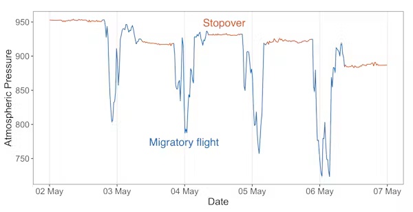
A graph showing atmospheric pressure over time. There are periods of steady pressure, with sharp drops in pressure occurring once per day.
Atmospheric pressure data collected from a multisensor geolocator carried by a yellow-rumped warbler over five days in spring. When the bird is stationary, such as when resting at a stopover site, the measured pressure remains steady. During migratory flights, when the bird ascends into the sky, the pressure drops and fluctuates dramatically. Stephanie Szarmach

New tech answers an old question

We used these new multisensor backpacks to study the migration patterns of myrtle warblers, the northern subspecies of yellow-rumped warbler, which breed across North America’s boreal forest. Myrtle warblers in the northeast are known to winter along the Atlantic and Gulf coasts, but where northwestern populations migrate has been more of a mystery. In 1899, ornithologist Richard McGregor observed myrtle warblers wintering in coastal California, and hypothesized that these birds might breed in Alaska and British Columbia.

Using these new tags allowed us to test whether warblers breeding in Anchorage, Alaska, actually followed the shortest migration route to winter in California. To our surprise – and probably to McGregor’s as well, if he were still alive – we found that all the birds we tracked traveled east across the boreal forest of Canada before shifting south to the Gulf Coast – certainly not the Pacific Coast route we expected.

All told, this 6,800-mile (10,900-kilometer) round-trip journey was much longer than we anticipated for a species commonly considered a short- or medium-distance migrant.
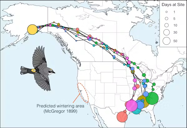
A map showing six geolocator tracks. All tracks start in Anchorage Alaska, before moving eastward across boreal Canada and then after reaching the Great Lakes curving south to end at the Gulf Coast. The predicted wintering area in California is circled.
Researchers tracked the routes six myrtle warblers flew on their fall migration southeast from Anchorage, Alaska. Figure by Stephanie Szarmach. Warbler illustration by Emily Griffith

Why take such a circuitous route?

The long, seemingly suboptimal route taken by our Alaskan myrtle warblers is actually mirrored by some other songbird species tracked from northwestern North America, including blackpoll warblers and Swainson’s thrushes.

Part of this pattern may relate back to the glaciations that isolated ancient populations of birds millions of years ago. The thinking goes that as these glaciers spread, they squashed the ranges of formerly northern species into the south. Then, as the glaciers slowly receded, the forests gradually reexpanded.

As more land opened up, birds moved farther north and west into that habitat. Each season some birds went a little farther as the forest available in their northern breeding grounds expanded. For migratory species such as myrtle warblers, the farther north and west their breeding range expanded, the longer the migration to their southern wintering ground became.

Scientists think migration routes are genetically encoded. The birds’ genes may have traced this expansion front, like Hansel and Gretel putting down breadcrumbs as they journeyed deeper and deeper into the forest. Today’s migration routes still trace that incrementally expanded path, even though the glaciers that shaped the original boundaries are long gone.

We’re still not sure exactly where the California-wintering myrtle warblers spotted in the 1800s are breeding. We suspect that a small proportion of the Anchorage-breeding birds may migrate to California, but that most of them travel from more distant, unstudied regions of Alaska or Yukon. Future research, potentially tagging myrtle warblers directly on the California wintering grounds, will shed more light on this population and why certain individuals follow a different migration route.

Barometric geolocation provides new data

Today, this new geolocation approach improves scientists’ ability to study the migrations of small birds and supports more effective conservation actions across the course of the entire year. More precise location estimates help researchers identify key stopover and wintering sites in need of protection and better understand the threats birds face throughout their journeys. These geolocators also reveal the altitude of migratory flights, which is important for understanding the risk of birds colliding with buildings or wind turbines.

Because these new tags capture pressure data for every migratory flight, they’re especially valuable for studying migration timing. Researchers have combined data from over 50 bird species to understand at what time of day or night different birds migrate. Now, as a postdoctoral researcher at the Smithsonian Migratory Bird Center, I am integrating multisensor geolocator data with satellite imagery to investigate how arrival and departure decisions throughout a bird’s migratory journey relate to seasonal changes in plant growth.

Scientists have now tracked dozens of bird species with multisensor geolocators, and that number increases every year. Each mapped migratory journey improves our understanding of how small birds migrate, what factors shape their movements and how best to protect them. This article originally appeared on The Conversation. You can read it here.

  • Why fall yard care could start with doing less – but not nothing
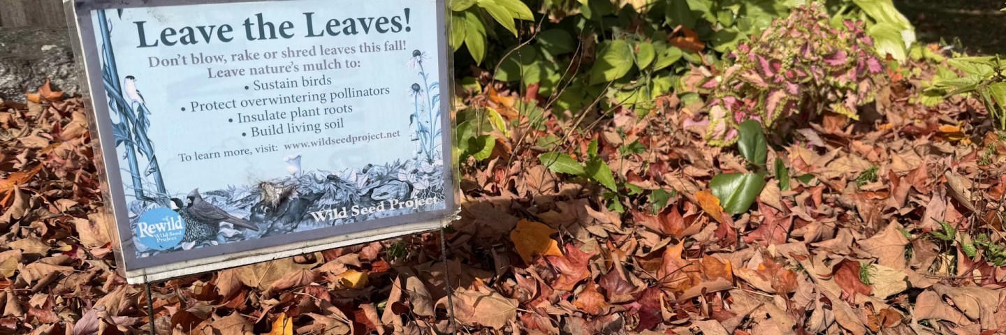
    Leaves on the ground are part of the natural cycle of nutrients. Manjot Sidhu, CC BY-SA
    ,

    Why fall yard care could start with doing less – but not nothing

    Fallen leaves shelter next spring’s pollinators and feed the soil. A horticulture specialist explains how to make room for both nature and a tidy yard.

    Assistant Extension Professor of Horticulture and Ornamental Horticulture Specialist, University of Maine

    Every autumn, homeowners and gardeners tend to engage in a familiar ritual. As trees shed their leaves, people drag out rakes, leaf blowers and lawn bags to strip their yards bare before winter arrives.

    It is a tidy habit rooted in aesthetics, but ecologically, clearing away fallen leaves strips the very foundation of local ecosystems. Far from dead debris requiring disposal, this fallen foliage forms a dynamic layer and a biological interface that drives nutrient cycling and is essential for soil health and the environment, including biodiversity.

    As a researcher of plant growth in yards and gardens, I would recommend leaving leaves on the ground. There, they can provide essential winter habitat for native pollinators – even in places that don’t have freezing temperatures. And they act as a nutrient-dense, natural mulch for the soil.

    Here is the science behind why the first step of fall yard care could simply be doing less – along with practical ways to keep your yard looking neat while nourishing the ecosystem underneath.

    A winter sanctuary for native pollinators

    To understand why leaf litter matters, it helps to look closely at what happens beneath the surface as temperatures drop. While honeybees pass the winter in sheltered hives, the vast majority of North America’s native pollinators do not.

    Up to 70% of native bee species, including many insects’ cocoons and larvae, nest in the ground. Fertilized queen bumblebees burrow just a few inches into the soil or hide under dense leaf mulch to survive the freezing months ahead, to lay eggs in the following spring.

    Raking, bagging and blowing leaves away destroys this crucial winter nursery.

    Many other insects depend on the shelter of fallen foliage:

    Nature’s engineered soil insulator and fertilizer

    In addition to being a shelter, fallen leaves are an evolved biological mechanism for nutrient cycling. Trees actively pump vital elements, including calcium, magnesium, potassium and nitrogen from deep subsoils, into their foliage. When autumn comes and leaves drop, these stored nutrients are deposited back into the soil.

    Leaving leaves in place triggers fundamental ecological benefits.

    A thick blanket of intact leaves acts as a natural insulator for the ground. Air pockets trapped between overlapping leaves moderate the soil temperature and slow heat transfer, buffering against the freeze-thaw cycles that heave soil, fracture plant roots and expose beneficial soil microbes to lethal cold. The intact leaf blanket also conserves moisture and prevents soil from drying out over the winter.

    As fungi, earthworms and micro-arthropods digest fallen leaves through late fall and spring, they break down organic matter into a rich material called humus. This slow-release organic fertilizer boosts soil structure, improves water retention in sandy soils, and prevents erosion and runoff in heavy rains.

    Decaying leaves feed beneficial mycorrhizal fungi in the soil. Those fungi form symbiotic relationships with plant and tree roots, helping the roots collect water and nutrients from the soil to nourish the plants above. A natural layer of leaves also suppresses spring weed seeds organically without needing synthetic chemical herbicides. And the moist, insulated microclimate under leaf litter is also critical for terrestrial amphibians, including frogs and salamanders, to survive freezing temperatures.

    How to ‘leave the leaves’

    Adopting a softer approach to fall cleanup does not mean your yard has to look completely untamed or that you have to risk killing your lawn. Here is how to balance suburban expectations with sound ecological science:

    • Move, don’t remove: Move the leaves from lawns and sidewalks, rake them into garden beds, around ornamental plants or into vegetable plots, using manual rakes or electric leaf blowers. Aim for a layer 2 to 3 inches deep. Leaving leaves in grassy areas can help ticks hide there too, but if you move the leaves to garden beds or spots that are used less, the ticks will be less likely to nest in the grass. Establishing pollinator zones on the property can also help reduce tick populations.

    • Skip the leaf shredder: Mowing over leaves with a mulching mower is better than sending them to landfills, but high-velocity mower blades still kill overwintering insect eggs, chrysalises and larvae. Leave leaves intact wherever possible in plant beds.

    • Wait for spring to clean up: Do not cut back hollow-stemmed perennials or clear leaf beds during early, warm spring days. Wait until temperatures consistently stay above 50 degrees Fahrenheit (10 degrees Celsius) so overwintering bees and butterflies have time to safely emerge.

    When you bag leaves for disposal and then buy commercial wood mulch or synthetic fertilizers in the spring, you are effectively paying a price for what your trees provided for free. By rethinking the cultural expectation of pristine autumn lawns, it’s possible to transform silent landscapes into vibrant habitat sanctuaries, simply by stepping back and allowing natural processes to take over.

    This article originally appeared on The Conversation. You can read it here.
  • How D.C.’s ‘humanure’ fertilizer creates lush gardens and big profits while improving the environment
    Photo credit: Canva – What you flush away could help your garden grow.

    The District of Columbia Water and Sewer Authority—now known as D.C. Water—has long provided water and sewer services to Washington, D.C. But for the past decade, the utility has also had an unexpected side hustle: turning human wastewater into fertilizer with flourishing results.

    At most wastewater treatment plants, flushed water is cleaned, while the remaining solid matter is hauled away for disposal. Over time, transporting and disposing of that waste can cost millions of dollars while increasing carbon emissions from the trucks carrying it. A decade ago, however, D.C. Water decided to invest in transforming the solid waste into “humanure” rather than throwing it away.

    Growin’ grass and makin’ gas

    At the end of the wastewater treatment process, the collected human waste solids are processed into biosolid fertilizer using technology developed by Norwegian company Cambi. The process doesn’t just produce high-quality fertilizer—it also generates biogas that can be put to good use.

    “So you get up to 40% more biogas,” Cambi CEO Eirik Fadnes said. “That biogas can be used to generate electricity to be used elsewhere in the wastewater-treatment plant or put on the grid and sold.”

    D.C. Water sells the biosolid fertilizer under the brand name Bloom, and it’s already proving to be a success. Bloom has been used throughout the Washington, D.C., area by customers including Catholic University, Mount Olivet Cemetery, and the Franciscan Monastery. It’s also used on numerous lawns, school grounds, community gardens, and golf courses.

    Success by the numbers

    The numbers underscore D.C. Water’s success. To date, nearly 400,000 tons of Bloom have been sold across Washington, D.C., Maryland, Pennsylvania, and Virginia, generating $13.6 million in revenue. D.C. Water originally estimated it would take 20 years for Bloom to pay off its investment. But thanks to strong demand from institutions, landscapers, and local garden centers, the utility is now on pace to recoup that investment in just 12 years.

    Bloom is also helping D.C. Water meet its environmental goals. By turning waste into a useful product instead of hauling it away for disposal, the utility has reduced its carbon footprint by roughly 50,000 metric tons of CO₂ emissions each year—the equivalent of taking more than 11,700 gas-powered cars off the road annually. The process also produces biogas, which can be converted into electricity to help offset the energy costs of wastewater treatment.

    Human waste works wonders

    None of this would matter if human biosolids weren’t effective at improving soil. “Humanure,” a term coined by Joseph Jenkins, refers to compost made from properly treated human waste. Because human feces can contain disease-causing pathogens, it must be handled carefully. After all, we call it “waste” for a reason.

    When human waste is composted correctly, naturally occurring microbes break down the organic material while generating enough heat to destroy harmful pathogens. Over time, the result is a nutrient-rich compost that can improve soil health. Some farmers even build specialized outdoor composting toilets to create humanure for use on their land.

    Should D.C. Water continue on this path of simultaneous profitability and environmental improvement, it’s likely other wastewater treatment plants will follow its lead.

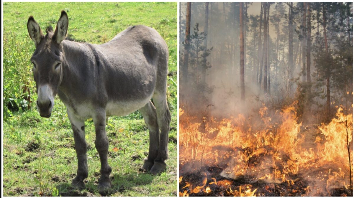
  • A Spanish park has been free of wildfires for over a decade thanks to 18 donkeys
    Photo credit: Canva – Donkeys and other livestock could help prevent mass wildfires.

    According to NASA, wildfires have doubled worldwide due to climate change. Throughout the globe, governments and environmentalists have been trying to find ways to curb the fires. One particular national park in Spain has found a solution that has been keeping them fire-free for over a decade: donkeys.

    Since 2014, the Firefighting Donkey Battalion unit consisting of 18 donkeys has been preventing wildfires in Doñana National Park in Doñana, Spain. The mission these donkeys do is simple: eat the dry brush that usually sparks and fuels wildfires. The donkeys spend up to seven hours a day using their voracious appetites to graze and clear a 130 by 50 feet area of dried grass, scrub, and other vegetation.

    Why donkeys?

    While humans can do this type of clearing out of dry brush, using donkeys for this work is arguably more effective. While it is a slower process, it is consistent and thorough. Donkeys are able to quietly patrol in areas that are inaccessible to vehicles. In exchange for the feasting, the donkeys get about eight gallons of water and rest. No money or fuel needed.

    The donkeys’ bodies are also pretty much built for this kind of environmental work, too. Their stomachs are built to eat the same rough and dry grass repeatedly without issues. These daily grazings slowly but surely remove potential origin sources for fires. As a bonus, the donkeys are naturally disposing of the dried vegetation whereas humans would have to find a different way to dispose of it.

    Having donkeys or other livestock graze in such areas was once more common in agriculture prior to modern farming. Some argue that the machinization of farming and urbanization have reduced the number of grazing animals. This in turn allows more vegetation growth that become dry spots for more wildfires to occur.

    The method expands

    This method has been so successful that other areas of Spain have adopted it. In 2020, Tivissa launched the Burros Bomberos project with three donkeys to so much success they’ve expanded. They now have 40 donkeys grazing and clearing nearly 400 hectares of land.

    The Andrea Association in Allariz uses a team of donkeys to clear and maintain nearly 1,000 hectares of a biosphere reserve. Using GPS to monitor the donkeys’ activity, the group of grazers travel 19 kilometers per day to feed. Similar initiatives have since started in Basque Country, Catalonia, and Galicia, too.

    Other ways to combat wildfires

    In the United States, California has been using goats in a similar function. The group Fire Grazers Inc. has been contacted throughout California to bring hundreds of goats to eat dried vegetation. Much like donkeys, goats are built to eat rough and dry brush. This includes certain plants such as star thistle that are painful for human hands to grab.

    It’s important to note that donkeys or other animals that eat dry scrub are the primary solution to wildfires. The same folks behind these initiatives also advocate proper forest planning and land management. This includes reducing the amount of easily flammable species of plants and trees such as pine. It takes thought, care, work, and maybe a bunch of donkeys to make a difference.

Explore More Science Stories

Science

New world map makes Africa look bigger: what’s the fuss about? Cartographers explain

Technology

Only 17% of people can pass this 3-question IQ test on the first try. Can you?

Exploration

Earth’s missing continent rediscovered 375 years after sailors first set foot there

Science

Compared to driving, flying is extraordinarily safe – but why doesn’t it feel that way?