Photo credit: Representative Image Source: A member of a small herd of Brumbies affectionally named moves through deep snow in the Long Plains area in Australia. (Photo by Brook Mitchell/Getty Images) – Array
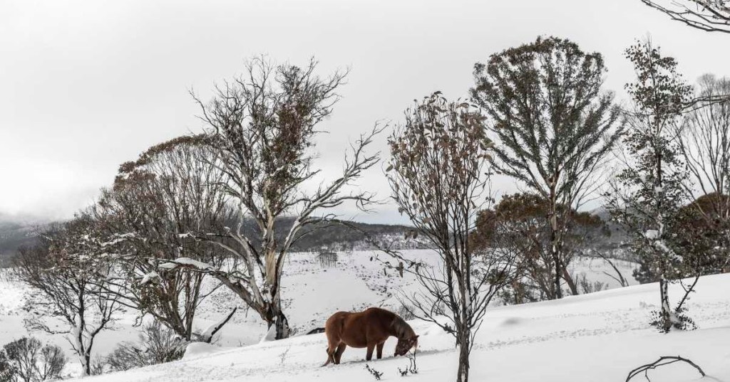
Optical illusions, much like puzzles, have a unique way of captivating the brain. By playing with colors, lights, and patterns, these illusions can make us see things that aren’t really there—or distort how we perceive them. In January 2024, during a snowstorm in British Columbia, Canada, Alesia Willard (@rudniktheroan) captured one such illusion while recording her horse. She posted the footage on TikTok, asking viewers if her horse was “walking towards her or away from her,” leaving the internet stumped.
Representative Image Source: Pexels | Solar Swallow
Rudnik is a 5-year-old blue roan and American quarter horse living with Alesia. The viral footage displays handsome Rudnik plodding in a beautiful contrast against a snow-white winter wonderland. In a valley covered with snow and bushes, the horse appeared so black that it was difficult to tell whether he was walking towards the camera or away. “When your horse is so black in the snow that you can’t tell if he is walking towards you or away from you,” Alesia wrote in the overlay text.
The video has been viewed over 16 million times and has gained more than 2 million likes since then. It not only left Alesia but other people perplexed too. “There were a couple of times I genuinely didn’t know,” she wrote in the caption. In the comment section, a discussion sparked on the topic of optical illusions. Most people found Rudnik’s footage “trippy.” Many said they couldn’t guess at all, while others said they were insanely confused. Several said that initially they were confused, but the direction of snow kicking gave them the clue that he was “walking away.”
Image Source: TikTok | @dumbrodeogirl2
“My head fell off watching this,” commented @tilltink93. @jjjn16 racked their brain and suggested, “If you look at the head it looks like it’s coming towards you. If you look at the rear it’s going away.” @themoodywife13 couldn’t guess, “The more I tried to tell the more I couldn’t. I had to look at his knees.”
The video was also shared on Instagram where it got more than 4 million views. @thattoddcuban commented on the footage, saying, “It literally changes direction halfway through is outstanding. Just watch the tail: first, it’s behind the horse, then it turns and the tail is behind it.” @jerremyrudnik quipped, “My last two brain cells fought to their last breath tryna figure this one out.”
Image Source: Instagram | @therobbielaw
In a series of Instagram posts, Alesia has revealed that she first came across Rudnik when he was 11 months old. He had a painful backstory. When he was just 9 months old, he was dropped at a livestock auction by his breeder, where he was set up for a certain slaughter. In his frenzy, the horse started behaving wildly, and seeing the wild horse, no one bid to buy him, except for a killbuyer. Soon enough, a well-known local rescue stepped forward and threw in their bid and the horse was set free for 50 bucks. This rescue owner gave Rudnik to another rescue owner and from there, Alesia eventually found him.
During the January snowfall, as Alesia was recording Rudnik in her camera, it took her a solid 10 to 15 seconds of watching him before she realized he was, in fact, walking away from her, she told Newsweek. She added that Rudnik is so dark against the snow, it is nearly impossible to distinguish his features. “I also realized that because he was so dark, it was hard to tell if he was coming or going at certain angles.”
Sadly, bat populations are declining rapidly in North America. A driving force is a fungal disease known as white-nose syndrome, which has spread among bats throughout the United States. When a bat population crashes, fewer bats are around to eat bothersome insects. All those additional insects can do serious damage.
A reproductive female big brown bat can eat its body weight in insects every night in the summer, precisely when farmers are growing food.
Mexican free-tailed bats head out of Bracken Bat Cave, near San Antonio, Texas, for an evening of feasting on insects. In summer, the cave is home to the largest bat colony in the world. Ann Froschauer/U.S. Fish and Wildlife Service
Farmers experience economic damage when rootworm concentrations exceed about 0.5 per corn plant. Typical planting densities exceed 30,000 corn plants per acre in the Midwest. Therefore, the rootworms that would have hatched could damage more than 2,000 acres of corn – if bats weren’t around to eat the cucumber beetles first.
That is a significant amount of pest control provided by bats!
The disaster known as white-nose syndrome
In the winter of 2006, the fungus that causes white-nose syndrome, the aptly named Pseudogymnoascus destructans, was first detected in the U.S. near Albany, New York.
From there, it spread across the country, infecting 12 species of bats, three of which are listed as endangered under the Endangered Species Act. A 2010 study found white-nose syndrome had killed between 30% and 99% of the bats in infected colonies.
As of March 2026, the fungus causing white-nose syndrome had been detected in 47 states, reaching as far west as California, Washington and Oregon. White-nose syndrome spreads primarily through bat-to-bat contact, though humans also contribute to the spread when cave explorers carry the fungus from one cave to another.
Despite coordinated efforts by state and federal wildlife agencies to limit access to caves where bats live and slow the transmission, white-nose syndrome continues to spread rapidly. When bats get infected, they wake up early from hibernation and use more energy over the winter. This depletes their fat reserves and causes them to die of starvation, leading to plummeting populations.
Bats’ role in food production
After white-nose syndrome arrives in an area, the loss of bats has significant consequences for farmers.
Yields fall as pests consume crops. To protect their crops, farmers purchase more chemical pesticides, so their costs rise as yields decline. The estimated agricultural losses from white-nose syndrome exceeded $420 million per year as of 2017.
A lesser long-nosed bat (Leptonycteris curasoae) feeding on an agave blossom in Arizona, spreading the flower’s pollen in the process. Rolf Nussbaumer/imageBROKER
Counties in all U.S. states tax agricultural land based on its “use value” – in other words, based on how profitable the land is in agriculture. Without healthy bat populations, lower profits shrink the tax base, leaving county governments with less revenue.
Those governments must respond by reducing services, raising taxes or increasing how much money they borrow – often at a greater cost of borrowing. The effect is especially pronounced in rural counties, where agriculture makes up a large share of property tax revenue.
Our recent research finds that rural county governments lost almost $150 per person in annual revenue after the arrival of white-nose syndrome. For an average-size rural county, that is nearly $2.7 million in lost revenue each year.
How losing bats can hit the bond markets
The loss of county revenue makes municipal bond investors nervous. Buying a municipal bond is a bit like lending money to the county, and the interest rate is what the county pays you for taking on that risk.
When bats disappear, the risk goes up, and the county has to pay about 11.47 hundredths of a percentage point more in interest. That may sound small, but it is 27% larger than the typical risk premium investors already demand from county governments.
The higher interest rate raises borrowing costs for county governments. For example, the borrowing costs on a typical 15-year, $1 million bond would increase by more than $33,000.
Bats snuggle up in a cave. Liz Hamrick/TVA
Higher yields also mean lower bond prices for investors, including retirement funds. For example, our research suggests that investors would discount a $1 million bond issued by a rural county by nearly $14,000 if that county’s bats have become infected by white-nose syndrome.
Economic benefits of saving bats
The good news is that the benefits from healthy bat populations create opportunities to make money from bat conservation.
Farmers can increase their incomes. Local governments can recover property tax revenue to fund public services, such as road maintenance, health infrastructure and public schools. Bond investors can earn financial returns from healthier bat populations.
No silver bullet exists for protecting or restoring bat populations affected by white-nose syndrome, but promising efforts are underway.
A fungal vaccine is being tested by the U.S. Geological Survey and partners. Designing artificial roosts and adding cave protections can also help preserve healthy bat populations. Researchers are also working to better understand bat resistance to the disease to explore whether improving resistance alone can stabilize bat populations.
As these solutions develop, opportunities will emerge for farmers, local governments and investors to earn financial returns through bat conservation. In other words, saving bats isn’t just good ecology – it’s good economics.
When was the last time you paid attention to your commute? And I don’t mean a couple of feet in front of you, at the car merging into your lane without a blinker. I mean really paid attention to the route you take.
Did you see the landmarks in the distance that make up the city skyline? Did you drive right past the grocery store you promised to stop by at the corner of this Peachtree Street or that Peachtree Street, a struggle Atlanta locals know well?
“Oops! Force of habit,” you might say to yourself as you miss your turn and begin to think about when and where you can turn around.
Relying on familiarity can either facilitate or impede daily navigation. As a researcher studying memory and navigation, I aim to understand how the brain supports spatial navigation and what happens if the cognitive mechanisms for choosing the best route home begin to decline, such as during stress or with aging.
Humans are creatures of habit – at least that’s what people tell themselves when wary of trying something new. But what if a new route is faster or safer than the one you usually take? Would you try it?
Research from my team suggests that people balance between exploration and habit – that is, trying something new or sticking with the familiar – when deciding what route to take. Which navigation strategy someone chooses depends not only on their spatial abilities but on their network of brain regions that support navigation.
Spatial navigation refers to the cognitive ability that helps you travel from one location to another. It may sound simple, but it requires using cognitive functions such as memory, attention, decision-making and assessing potential rewards – never mind the ability to simply perceive the environment itself.
For example, you might retrieve an episodic memory about a specific event: remembering a detour you took a week ago to drop a package off at the post office, including the traffic and weather that day.
You might also retrieve a semantic memory that’s more factual and knowledge-based: remembering how many blocks away the post office is from the park and the turns you need to make to get there.
Together, these kinds of memory inform your spatial memory, which allows you to retrieve location information. This could be where buildings are in relation to each other or where objects are situated in your house. Spatial memories help form your cognitive map, which is essential for getting around in the world.
Often, these different ways of remembering interact, and you can use one type of memory to inform the other. For example, you’ve become accustomed to your commute to work and know it’s relatively short (semantic memory), but over the past three days you’ve been arriving late due to heavy traffic (episodic memory), so you choose to take a different route next time.
Research from my team has found that disagreements in your brain over possible routes can happen. Different types of memory can come up with different solutions for what route you can take, and this conflict is a big factor in how hard your brain needs to work when navigating an environment.
Responding to new and familiar memories
Habits stem from what researchers call stimulus-response memories. These include the knee-jerk reaction you might have to familiar landmarks – when you perceive these places, your brain signals you to make a turn along your commute without needing to consciously think about it.
Habits are rigid, but they can also be beneficial: By taking care of the navigation for you, habit frees up your brain to have a conversation with someone or plan what to make for dinner when you get home.
When navigating less familiar routes or environments, where habit doesn’t kick in automatically, you rely on brain regions such as the hippocampus to call on detailed memories from recent experiences to help guide the way.
But let’s say you’re shopping at a new grocery store where most things are where you expect them to be, even though you’ve never been in this particular store before. What happens when your brain experiences both something new and something familiar about an environment?
Researchers have shown that when something about an environment is familiar and aligns with your prior experiences, the prefrontal regions of your brain – those responsible for executive functions such as decision-making – become more active. They can bypass or even inhibit your hippocampus’s ability to form new memories about specific events.
In other words, your brain can weave information about a new experience into your database of existing knowledge, rather than storing it as completely new information with little relation to the past. This process may help fast-track your understanding about new experiences.
Updating cognitive maps
Researchers know that cognitive maps of the environment depend on the hippocampus and its database of memories about specific events. However, I and other researchers argue these maps can also function as a schema – a collection of memories made up of associations between environmental details. You can add new information to these collections and use it to infer new relationships.
Say a new pedestrian bridge is built between the park and the post office. Your brain can more easily weave this new route information into your existing memories compared with learning a new environment from scratch. Similarly, if you just moved to a new town and know very little about the spatial layout, you might rely on your past experiences of towns to infer where something is.
Using neuroimaging techniques as well as virtual reality programs designed to test a participant’s ability to navigate different routes, my team found that there is likely an interdependent relationship between the brain areas that store memories of specific events and areas that store related information across memories when planning to navigate less familiar places.
New routes are more difficult to follow when they differ from your prior experiences. Thus, a stronger schema helps integrate your knowledge of the spatial relationships between locations and landmarks (such as the distance between the post office and the park) with more general knowledge (such as prior route difficulty). This all informs how you choose to navigate.
Navigating daily life
These memory principles help explain why inconsistencies with your previous experiences can make it so difficult to navigate many aspects of daily life.
Imagine you woke up tomorrow and the GPS on your smartphone was no longer available. How will you plan your route to get to your destination?
You might be used to navigating north from your home to the grocery store – but have you ever tried to navigate to that grocery story from a different location? It’s much harder!
Relating new information to your prior experiences may help strengthen your schema and make navigation easier. And understanding what processes the brain needs to go through to solve these navigation problems can help you understand why getting around can be challenging.
When these plots are planned — as opposed to letting vacant lots grow wild, which is valuable in its own right — they become extra powerful. You may have even enjoyed one without knowing it: the “pocket garden.” Tucked into spaces accessible to pedestrians, like sidewalks, hospital grounds, and campuses, they can be engineered to turn heat-absorbing concrete into air-cooling oases packed with vegetation and seating for people to escape the metropolitan bustle.
“This increasing prioritization of creating green spaces in unexpected spots and underutilized spaces in communities is not only going to be making our communities more resilient, it’s going to be making people healthier,” said Dan Lambe, chief executive of the nonprofit Arbor Day Foundation, which promotes urban forestry. “A little bit of green goes a long way.”
Pocket gardens aren’t gardens in the agriculturally productive sense, but ornamental grounds, Grist reports. (Though there’s nothing stopping a designer from adding a fruit tree or two.) Ideally, they’re host to native plant species, which bring several benefits. For one, they attract native pollinators like insects and birds, which get a source of food that powers them to go on and fertilize plants elsewhere, like crops in urban farms. And two, if the vegetation is adapted to a particular region or condition, it’s already used to the local climate — drought-tolerant varieties, for instance, won’t require as much water to survive. Furthermore, choosing native grasses that don’t need mowing can cut down on maintenance costs. And picking trees with big canopies will increase the amount of shade for people to use as refuge from the heat. (Sorry, palm trees, that means you’re disqualified.)
Biodiversity — mixing tree species as opposed to planting 10 of the same kind — is key here. That attracts a broader range of pollinating animals, and builds resiliency into the system: If you only plant one variety of tree and a disease shows up, it can spread rapidly.
And speaking of disease, trees have an additional superpower in their ability to scrub urban air of the pollutants that contribute to respiratory problems. In addition, the vegetation of a pocket park releases water vapor, bringing down air temperatures. This mitigates what’s called the urban heat island effect, in which cities absorb the sun’s energy all day and slowly release it into the night. Combined, reduced air pollution and temperatures improve public health.
There’s also the harder-to-quantify bonus of people getting out of their cars and gathering in public spaces, no matter how diminutive. “It’s actually a transition toward the pedestrian — toward the person — and away from the vehicle,” said Eric Galipo, director of campus planning and urban design at the architecture firm FCA, which has integrated pocket gardens in its projects. “We may not spend as much time together as a society as we used to, and so these are great opportunities for that sort of connection to happen.”
When the rains come, these verdant plots take on another role as an infrastructural asset. As the planet heats up, rainfall increases because a warmer atmosphere can hold more moisture. In response, cities like Los Angeles and Pittsburgh are getting rid of concrete to open up more green spaces, which absorb rainfall, allowing it to seep underground. This reduces pressure on sewer systems that are struggling to handle increasingly heavy deluges. These systems, after all, were designed long ago for a different climate than we’re dealing with today.
When a city prioritizes green spaces, you can actually hear the difference. Barcelona, for instance, has been developing superblocks, which aim to improve city life by transforming car infrastructure into walkable spaces. That includes the development of “green axes” (the plural of “axis,” not the tool for chopping), full of vegetation and paths for strolling. A recent study found that after these spaces were pedestrianized and vehicles disappeared, average noise levels fell by 3.1 decibels. (For context, hearing a car traveling at 65 mph from 25 feet away would be 77 decibels.)
While 3.1 may not seem like much, each increase of 10 decibels means a tenfold rise in loudness. And we have to consider not just the decibels but how the kind of noise changed as Barcelona developed green axes: Revving engines, honking horns, and even the occasional cacophony of a car accident were replaced with voices. As the built environment dramatically changed, so too did the way that folks on foot experienced their surroundings. “If people see green in general, the noise perception tends to change,” said Samuel Nello-Deakin, a postdoctoral researcher at the Autonomous University of Barcelona and lead author of the study. “You think that things are not as noisy as they actually are. So there’s also this interesting interaction, right, between sort of what you hear and what you see.” In addition, green spaces absorb city racket, keeping it from bouncing off of and between buildings and pavement, insulating residents from the din.
With less commotion comes still more gains to public health. Noise pollution is an invisible crisis worldwide, as studies link the stress it causes not just to struggles with mental health, but physical problems like hypertension and heart disease. By contrast, pocket parks and other green spaces encourage people to ditch their cars and move their bodies. “There are also physical health benefits from walking, biking, and being outside that over a lifetime tend to have a cumulative positive effect on what our society spends in health care,” Galipo said.
So as cities increasingly realize and utilize the power of greenery, the environmental, auditory, and social fabric of the urban landscape transforms. “There’s a gravity to this green space that brings people out,” Lambe said. “And all of a sudden, neighbors are connecting, generations are connecting, cultures are connecting. Trees are about the one thing that everybody can agree on.”