It's about 11.7 million square miles, which is really big—big enough to fit the United States, China, India, Japan, and much of Europe within its borders. And that's precisely what Kai Krause did with this inventive map, "The True Size of Africa," which he describes as his contribution to "the fight against rampant Immappacy."
What is immappacy? Krause explains:
In addition to the well known social issues of illiteracy and innumeracy, there also should be such a concept as "immappacy," meaning insufficient geographical knowledge.
A survey of random American schoolkids let them guess the population and land area of their country. Not entirely unexpected, but still rather unsettling, the majority chose "1-2 billion" and "largest in the world," respectively.
Even with Asian and European college students, geographical estimates were often off by factors of 2-3. This is partly due to the highly distored nature of the predominantly used mapping projections (such as Mercator).
A particularly extreme example is the worldwide misjudgment of the true size of Africa. This single image tries to embody the massive scale, which is larger than the USA, China, India, Japan, and all of Europe ... combined!
Brilliant. See the large version here.






 An octopus floating in the oceanCanva


 A woman relaxes with a book at homeCanva
 An eviction notice is being attached to a doorCanva
 Gif of Kristen Bell saying 'Ya basic!' via
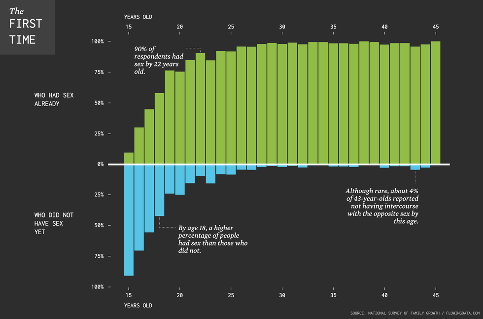 The chart illustrates that between ages 16 and 20, roughly half the population loses their virginity. By age 22, 90% of the population has had sex.
 A group of young people hold their phonesCanva
 (LEFT) Judy Garland as Dorothy Gale and (RIGHT) Ray Bolger as Scarecrow from "The Wizard of OZ"CBS/
  (LEFT) The Wonderful Wizard of Oz children's novel and (RIGHT) The Wizard of Oz movie poster.William Wallace Denslow/
 A frustrated woman at a car dealershipCanva
 Bee Arthur gif asking "What do you want from me?" via