People who rent their homes, or don’t have enough money to make major upgrades to their homes, have for many years been left out of a major shift in heating and cooling technology that can improve efficiency, save money and be better for the global climate: heat pumps.

Heating and cooling buildings consumes 35% of all the energy used in the United States each year. Many homes and businesses are converting their fossil fuel-powered heating and cooling systems to electric-powered heat pumps, which use electricity not to generate hot or cold air but to move heat into spaces needing warmth and out of spaces needing cooling.

Until recently, that process has required a significant amount of sizable and expensive equipment to be permanently installed in a building, which needs a professional contractor and can cost as much as US$10,000 just for the installation – in addition to the actual equipment. Often called mini-splits, these systems usually have a condenser outside the building that exchanges heat with the outdoor air and an evaporator inside that exchanges heat with the indoor air.

A woman stands in a room looking at a boxy piece of equipment in her window.
The New York City Housing Authority has been installing window-mounted heat pumps in apartments, like this one in Queens. AP Photo

But now window heat pumps are becoming available in the U.S. Much like a window air conditioner, these self-contained devices can be installed without professional help and plugged into a wall outlet. Unlike window air conditioners, though, they can provide heat as well as cooling. They cost much less than a permanent system – between $3,000 and $4,000 – and can be moved to a new property if the owner relocates.

There aren’t many options commercially available yet, and those on the market can’t heat or cool very large spaces on their own. And they work less efficiently when heating homes in places with extremely cold outdoor temperatures. A few models are available on the market that are even cheaper, but they don’t have efficiency ratings, don’t work when outdoor temperatures are very cold, and are louder when running.

I have designed and evaluated a wide range of building energy efficiency technologies; here’s how these window heat pumps work, and why they may allow apartment dwellers and residents of older houses to easily and relatively inexpensively make significant improvements to their homes’ heating and cooling systems. Federal subsidies for this type of equipment expired in 2025, but some utility companies, states and local governments may still offer money to help pay the costs.
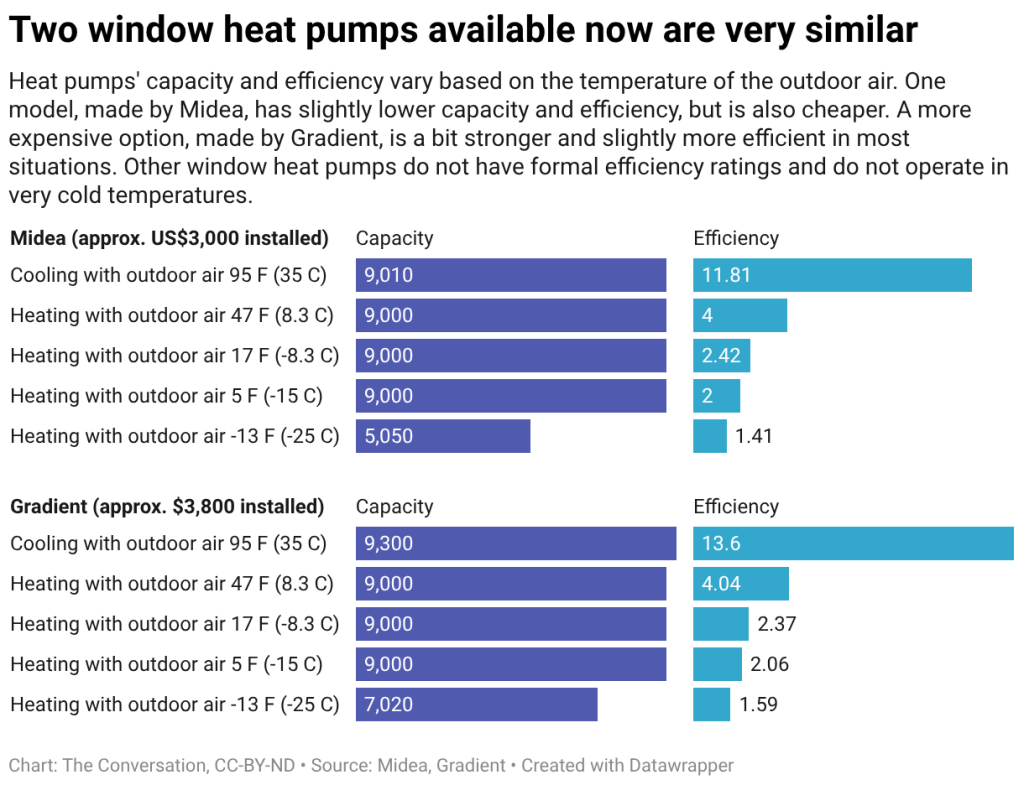
Two window heat pumps available now are very similar

Moving heat from one place to another

Heat pumps use a reversible refrigeration cycle and can provide similar heating and cooling as electric-powered space heaters, furnaces and baseboard heaters, while using less than half the electricity.

The most common heat pumps transfer heat between air indoors and outdoors, but other systems can exchange heat with the ground or with bodies of water, such as lakes.

Heat pumps’ capacities are defined by the amount of heat they can transfer in a particular period of time. A heat pump serving an entire home may need a capacity of 12,000 to 60,000 British thermal units (about 12,660 to 63,300 kilojoules) – but the window units’ capacities are much lower, getting up to only about 9,000 Btu (9,500 kJ).

Performance varies based on the conditions outdoors, where the unit is either sending excess heat to cool the indoors or gathering heat to warm the indoors. In cooling mode, heat pumps are rated by their seasonal energy efficiency ratio, a figure that indicates how much cooling is achieved per unit of electricity used. The corresponding measurement for heating is called heating seasonal performance factor. In general, the larger these numbers are, the better they will perform. The U.S. Department of Energy has established minimum standards for those figures.

While these units operate even when outdoor temperatures are -13 degrees Fahrenheit (-25 degrees Celsius), their heating output is reduced to almost half of its rated capacity, and their energy efficiency falls to one-third of its rated performance at that temperature.
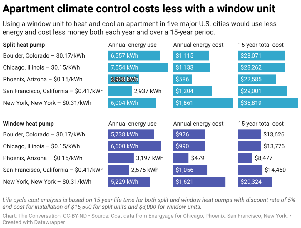
Apartment climate control costs less with a window unit

In addition to their low cost compared to conventional split heat pumps, packaged window heat pumps meet heating and cooling needs with lower energy demands and costs. But each window unit serves just one room, while a more common split unit can serve multiple rooms.

Packaged window heat pumps are easy and inexpensive to install and offer all-in-one heating and cooling options for apartments and older homes, with higher energy efficiency performance than traditional systems. Their main limitations include their low capacities and reduced energy efficiency in extremely cold climates or conditions.

This article originally appeared on The Conversation. You can read it here.
  • New world map makes Africa look bigger: what’s the fuss about? Cartographers explain
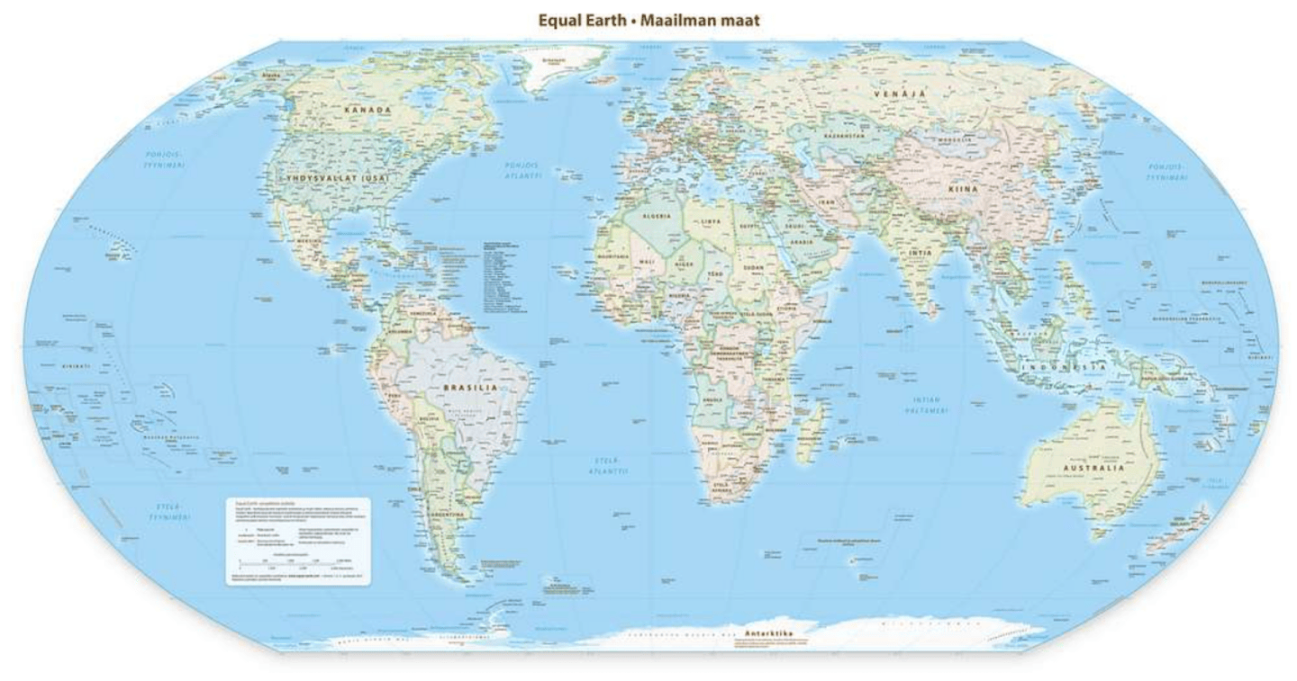
    A political wall map using the Equal Earth projection centred at the prime meridian. Wikimedia Commons

    The UN has passed a non-binding resolution to endorse the Equal Earth Projection, a map which more fairly represents the true size of the Earth’s landmasses. The current commonly used projection, called the Mercator Projection, greatly exaggerates land towards the north and south poles, which makes Africa look much smaller. In the Mercator projection, countries near the north and south pole can be anywhere from two to 14 times their true size. In the Equal Earth projection these distortions are minimised, making Africa look larger in comparison.

    We asked Jack Swab and Derek Alderman, cartographers and geographers who study the social and communicative power of maps, to explain what’s going on.


    What is a map projection?

    A map projection is a technique that cartographers (map-makers) use to transform the round, three-dimensional Earth into a flat, two-dimensional map that we see on the wall or on our computer screen. As cartographers flatten the globe, the map becomes distorted, changing shapes and areas. There is no map projection that does not distort the Earth, but some projections are better suited for some uses than others.

    A cartographer’s job is to choose from the hundreds of different map projections, and consider where the map is focused and how it is going to be used. No single projection is best for every use. This new Equal Earth projection is better suited than Mercator for producing global scale world maps for educational, public communication and policy purposes.

    The Equal Earth supports a more accurate geographic understanding of the relative sizes of countries and continents. It provides a fairer perspective for the public to compare regions in terms of population, environment, development, politics and other global patterns.

    Is the Mercator projection still useful?

    While the Mercator projection isn’t good for showing the size of the Earth’s landmasses, we won’t see it totally disappear. For example, it’s very useful for navigational purposes as it maintains the accuracy of a compass bearing between two points without having to recalculate it.

    This is why most online mapping platforms like Google Maps or Apple Maps rely on a variation of the Mercator projection to provide directions. Using the Equal Earth projection for navigation would not be as effective as the Mercator projection.

    How will the Equal Earth projection be used?

    Map-making is decentralised and there is no single authority regulating which map projection is used. What the UN did was endorse the broader message that Equal Earth is a fairer projection that more equitably displays the true size of the Earth’s land. And although this action is happening at a global level, there are movements underway in cartographic communities to make the Equal Earth projection the default world map projection.

    The UN resolution by itself will not make Equal Earth a globally adopted projection. That requires intentional revision of maps used in textbooks, databases, media productions and diplomatic discussions, which requires labour and financial investment.

    The Equal Earth projection was developed by cartographers and is a popular choice among map-makers since it was unveiled in 2018. It’s now possible to buy wall maps with the Equal Earth projection on them, and the projection has already been used in a wide variety of media. That said, individuals will need to opt in to using the Equal Earth projection over other types.

    Why has the Equal Earth projection sparked resistance?

    Resistance to the Equal Earth projection has been quite limited. There were several abstentions from the United Nations General Assembly vote, but most of this was for other reasons. Ukraine, for example, raised concerns over the depiction of the contested Crimean Peninsula on the map, which the Equal Earth Projection website depicts as contested territory.

    This spurred a Russian response, along with points from other nations about contested territory. Given the UN resolution was a vote on how the world is portrayed and not about any specific political boundaries (a point that both Russia and Ukraine agreed on), these discussions amounted to geopolitical posturing about non-map issues.

    The lone outlier, and only “no” vote against the Equal Earth projection, came from the United States. It claimed that the proposal was part of a “radical and ideological project” that was not appropriate for the United Nations to be debating. American delegates took issue with language linking Mercator’s distortions to colonial legacies and the marginalisation of Africa. This is not surprising since the current administration denies the existence of structural systems of inequality.

    It is hard to miss the hypocrisy at play. The US wants other countries not to discuss the political implications of cartography even as President Trump engages in his own nationalist branding of the map. He has unilaterally renamed the Gulf of Mexico to the Gulf of America and Lake Ontario to Lake America for clear ideological reasons and without international consultation.

    How does the new map matter when it comes to changing global views of the world?

    The argument that African nations put forward was that the Equal Earth projection is a form of “cognitive justice”. Cognitive justice recognises that people often equate power and value of places with their apparent size on maps. Traditional views of Africa as a smaller continent compared to Europe or North America typically reflect the perceived importance of these parts of the world.

    Equal Earth may make it easier to teach, broadcast and discuss a different view of Africa and its prominence in the world. Today, African countries are among the world’s fastest growing economies and fastest growing populations. Map projections alone cannot change people’s attitudes. Yet, as African nations seek to have more influence in international affairs, correcting the mental map of global leaders is an important step in amplifying the continent’s relevance and rights.

    Jack Swab, Assistant Professor Department of Geography & Sustainability, University of Tennessee and Derek H. Alderman, Chancellor’s Professor of Geography, University of Tennessee

    This article originally appeared on The Conversation. You can read it here.

  • Only 17% of people can pass this 3-question IQ test on the first try. Can you?
    Photo credit: Canva – A woman writes on a chalkboard
    , ,

    Only 17% of people can pass this 3-question IQ test on the first try. Can you?

    Developed by a Yale professor, this simple test reveals a lot about how you think—and only 17% of people get it right.

    It’s been called the world’s shortest IQ test, and despite its apparent simplicity, only about 17% of people answer all three questions correctly on their first try. The Cognitive Reflection Test (CRT) isn’t about measuring knowledge; it’s about measuring how you think.

    The test was introduced in a 2005 paper in the Journal of Economic Perspectives by Yale professor Shane Frederick. It’s designed to test your ability to override a quick, intuitive gut reaction and engage in deeper, more analytical thought.

    Want to try it yourself?

    IQ test, cognitive reflection test, critical thinking, brain teasers, logic puzzles, psychology, System 1 thinking, problem solving
    Woman sits in front of her computer thinking Canva

    Here are the three questions:

    1. A bat and a ball together cost $1.10. The bat costs $1.00 more than the ball. How much does the ball cost?
    2. If it takes five machines five minutes to make five widgets, how long would it take 100 machines to make 100 widgets?
    3. In a lake, there is a patch of lily pads. Every day, the patch doubles in size. If it takes 48 days for the patch to cover the entire lake, how long would it take for the patch to cover half of the lake?

    The Answers and Why They’re So Tricky

    If you answered 10 cents, 100 minutes, and 24 days, you’re in the majority—and you’ve fallen for the trap. Those are the common intuitive answers. The correct answers are 5 cents, 5 minutes, and 47 days.

    IQ test, cognitive reflection test, critical thinking, brain teasers, logic puzzles, psychology, System 1 thinking, problem solving

    Woman proudly shows testy results Canva

    Here’s the breakdown:

    • The Bat and Ball: If the ball cost 10 cents, the bat (at $1.00 more) would cost $1.10, for a total of $1.20. The correct math shows the ball is 5 cents and the bat is $1.05.
    • The Widgets: The rate of production is one widget per machine every five minutes. Therefore, 100 machines can produce 100 widgets in the same five-minute timeframe.
    • The Lily Pads: Since the patch doubles in size every day, it must have been half its final size just one day before it covered the whole lake—on day 47.

    The Science of Your Brain

    IQ test, cognitive reflection test, critical thinking, brain teasers, logic puzzles, psychology, System 1 thinking, problem solving

    An artistic representation of the brain Canva

    This test brilliantly illustrates the two modes of thinking identified by Nobel Prize-winning psychologist Daniel Kahneman. System 1 is our fast, automatic, intuitive thinking, which gives us the quick (but wrong) answers. System 2 is our slower, more deliberate, and analytical thinking, which is required to solve the puzzles correctly.

    As Frederick explains, the test measures how we make decisions based on instinct versus analysis. “System 1 thinkers respond spontaneously, often making mistakes, while System 2 thinkers engage in effortful thought processes,” he wrote.

    Frederick’s research found that those with stronger cognitive reflection skills (System 2 thinkers) tend to be more patient and willing to take calculated risks. His work aims to understand the real-world impact of our cognitive styles, noting, “Despite the diversity of phenomena related to IQ, few have attempted to understand—or even describe—its influences on judgment and decision making.”

    So, whether you passed the test or not, it offers a fascinating glimpse into the constant tug-of-war between gut reaction and careful thought that happens inside our brains every day.

    This article originally appeared earlier this year.

    This article originally appeared [time-difference] ago. It has been updated.

  • Earth’s missing continent rediscovered 375 years after sailors first set foot there
    Though mostly submerged now, Zealandia is a real place.
    ,

    Earth’s missing continent rediscovered 375 years after sailors first set foot there

    Long overlooked and mostly underwater, Zealandia is rewriting what we know about Earth’s continents.

    Earth still holds remarkable secrets beneath its surface—and sometimes beneath its oceans. In 2017, scientists confirmed the existence of a hidden continent beneath the South Pacific. Now known as Zealandia, this mostly submerged landmass was found hiding in plain sight and has since been dubbed “the eighth continent.” A study published in Tectonics helped solidify its status, offering a new perspective on Earth’s ever-evolving geography.

    The long search that began in the 1600s

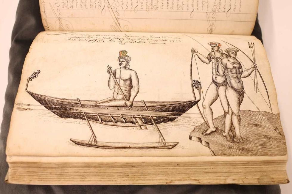
    Although the researchers discovered this new continent in 2017, the hunt began almost 400 years ago. In 1642, Dutch captain Abel Tasman (seen in the above portrait), serving the East India Company, was ordered to explore a Southern Continent. On August 14, 1642, Tasman departed from Batavia with two ships sailing west to Mauritius in the Indian Ocean, according to Princeton University Library.

    zealandia, logbook, lost continent
    A detailed view of the logbook of navigator Abel Tasman (Dutch East India Company) from 1642 Dean Mouhtaropoulos/Getty Images

    Tasman named the location “Moordenaers (Murderers) Bay,” and sailed home, never to return to this land, although he did believe that he had discovered a great new continent.

    Naming and defining Zealandia

    It was nearly 375 years after Tasman’s voyage that geologists stumbled upon this mainland. They announced the discovery by naming it “Zealandia,” based on the suggestion of American geophysicist Bruce Luyendyk who described this region in 1995. Zealandia is translated to “Te Riu-a-Māui” in the Māori language.

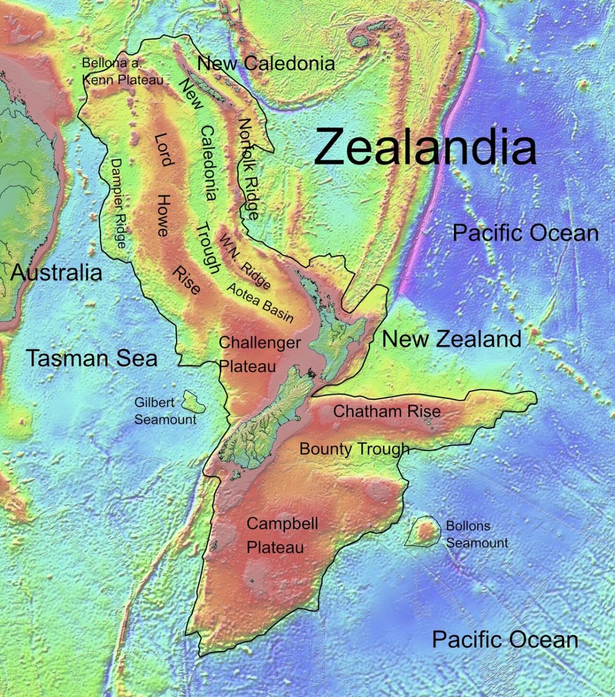
    Zealandia lies mostly submerged off the east coast of Australia Public Domain

    In a paper, researchers from GNS Science of New Zealand documented that they had to dredge rock samples from the Fairway Ridge to the Coral Sea to analyze the rock geochemically and understand the underwater makeup of Zealandia. Led by Nick Mortimer, they scanned the northern two-thirds of the submerged area, where they unearthed pebbly and cobbley sandstone, fine-grain sandstone, mudstone, bioclastic limestone, and basaltic lava from a variety of periods as concluded by their radiocarbon dating.

    Ancient rocks with a story to tell

    The rocks and stones were found to be roughly 95 million years old, from the Late Cretaceous period. The granite and volcanic pebbles were estimated to be 130 million years old, the Early Cretaceous period. The basalts however were newer, probably about 40 million years old, and from the Eocene period. “It is kind of cool,” said Mortimer, per BBC. Andy Tulloch, a geologist at the New Zealand Crown Research Institute GNS Science, who was part of the research team, added, “This is an example of how something very obvious can take a while to uncover.”

    Mostly submerged, yet massive

    Although Zealandia is a vast continent that spans an expanse stretched for 4.9 million square kilometers, around six times the size of Madagascar, most of it is submerged under the South Pacific Ocean. Only the area at the Ball’s Pyramid on Lord Howe Island rises above the water’s veil. It is the smallest, thinnest, and youngest of all known continents.

    Usually, the continental crust is about 40 kilometers deep, thicker than the oceanic crust which is about 10 kilometers. The researchers proposed that since Zealandia ended up stretched too much, its crust became thinner, around 20 kilometers, and finally disappeared under the sea. With 95 percent of its territory submerged beneath the ocean’s depths, Zealandia prowls on planet Earth as a lair possessing an enigmatic charm of mysterious historical elements and ancient stories.

    This article originally appeared last year.

    This article originally appeared 1 year ago. It has been updated.

Explore More Science Stories

Science

New world map makes Africa look bigger: what’s the fuss about? Cartographers explain

Technology

Only 17% of people can pass this 3-question IQ test on the first try. Can you?

Exploration

Earth’s missing continent rediscovered 375 years after sailors first set foot there

Science

Compared to driving, flying is extraordinarily safe – but why doesn’t it feel that way?