Earth’s ever-shifting tectonic plates constantly reshape continents and landscapes. Over millions of years, these movements have transformed the planet, even causing the disappearance of an entire continent beneath the ocean. Recently rediscovered, Zealandia has finally been fully mapped, according to Forbes. It’s the first continent to be completely mapped and the first ever done under the sea.
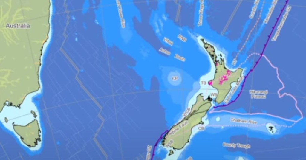
Zealandia, the eighth continent, lies off the shores of New Zealand. Known as Te Riu-a-Māui in Māori, it spans 5 million square kilometers. The continent remained hidden from view, as 95% of it is submerged beneath the southwest Pacific Ocean. Only a few plateaus and mountain peaks are visible, which led to its discovery. The name “Zealandia” comes from the isolated islands of New Zealand and New Caledonia, according to the Geological Society of America.
GNS Science shared an animation of the continent developing over the years to become visible as a separate continent on the map. In a 100-million-year revolution and shift, the continent came to be formed. The caption read, “GNS scientists have produced brand new maps of the continent of Te Riu-a-Māui / Zealandia showing how the shape of our islands has developed over millions of years.”
A study in the Tectonics Journal also revealed the map marking Zealandia and its boundaries among the water bodies and continents. The map vividly shows North and South Zealandia along with the plateaus, sea, oceans and so on. Geologists have a theory about the formation of the continent. They believe the same began as a result of a scar in the Earth’s crust. This supposedly took place when Zealandia broke off from Antarctica and Australia about 150 million years ago. What followed was the continent making its own landmass and thinning and stretching to become a continent.
Four key attributes qualify a landmass as a continent: elevation, geology, crustal structure, and area. Zealandia meets these criteria. It is elevated above the oceanic crust with wider and deeper shelves than many other continents. The highest point is Aoraki–Mount Cook at 3,724 meters. Geologically, Zealandia contains the necessary sedimentary and metamorphic rocks, such as Paleozoic and Mesozoic greywacke, schist, and granite, classifying it as a continental area.
Like several other continents, Zealandia also has a thick and varying crust. The thickness typically ranges from 10 to 30 km throughout its entire extent to over 40 km in certain parts. Though thinner than others in most of its area, it passes off as a continental structure. Lastly, continents require a visible ocean-continental boundary and Zealandia fulfills the criteria. The edges of the Australian and Zealandia continental crust are around 25 km across the Cato Trough. All and all, it is an exciting feat for Geologists.
This article originally appeared on 07.26.24.


