When we’re taught history, one of the first things we learn is about ancient maritime exploration. But we’re often missing something: we know that people traveled by boat, of course, but what we often don’t know is how. Scientists at the National Museum of Nature and Science in Tokyo, among other institutions in Japan and Taiwan, now have an answer to the latter.
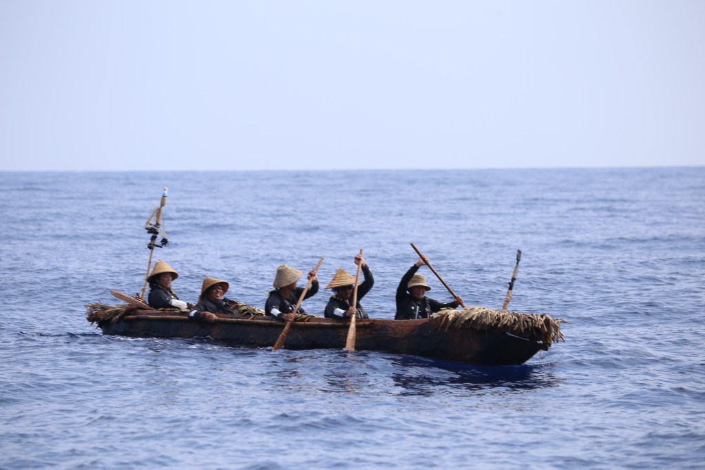
In a project that took six years, these scientists learned exactly how ancient peoples traversed dangerous currents to travel from Taiwan to Japan by doing it themselves. It took 45 hours to complete the 140-mile journey in a dugout canoe crafted from a single Japanese cedar. In doing so, they revealed exciting facets of history that had once been unknown.
In the course of their research, scientists learned “that around 30,000 years ago, humans made a sea crossing—without maps, metal tools or modern boats—from what is now called Taiwan to some of the islands in southern Japan, including Okinawa,” the University of Tokyo shared in a press release. The goal this team of 60 scientists had was to learn how they did it by initiating their own experimental archaeological test: which is to say, they’d do their best to create a scientifically and historically accurate duplication of how ancient peoples did it tens of thousands of years ago.
This included first figuring out the best kind of boat material to choose: early choices of reed and bamboo did not cut it and could not withstand the dangerous Kuroshio current, one of the strongest in the world. The next choice became a dugout canoe, which was made from a hollowed out tree with tools modeled after those that would have been used in the Stone Age. Still, this boat needed work: the initial model would flip over in the rushing water. Eventually, scientists were able to forge a version that worked after burning and polishing parts of the canoe and making several test trips.

Five members of the team set sail on their voyage in June 2019, and the results of their experiment have just recently been published. Like the travelers before them, they too used no maps or compasses and had only their knowledge of wind, sky, water, and instincts to guide them, the University of Tokyo shared. Their journey paddling, often for many hours without stopping, was a taxing one, and gave insight into what ancient peoples must have endured.
Scientists also learned there was no way ancient peoples came across any of this information by accident. Quite the opposite: it took a huge knowledge base and high levels of navigational skill to complete such a task, they wrote, not to mention incredible perseverance and strength. “Those male and female pioneers must have all been experienced paddlers with effective strategies and a strong will to explore the unknown,” project leader Professor Yousuke Kaifu said.

Their experimental archaeological expedition also revealed that it would have been difficult to go home once they arrived. “We do not think a return journey was possible. If you have a map and know the flow pattern of the Kuroshio, you can plan a return journey, but such things probably did not take place until much later in history,” Kaifu said. This means it’s possible that once these Paleolithic explorers left home, they may not have returned.
“Scientists try to reconstruct the processes of past human migrations, but it is often difficult to examine how challenging they really were,” Kaifu said. “One important message from the whole project was that our Paleolithic ancestors were real challengers. Like us today, they had to undertake strategic challenges to advance.”